


Természetjáró, a túratervező
Beschreibung von Természetjáró, a túratervező
Der Online-Reiseführer für Ungarn, speziell entwickelt für Wanderer, Biker, Trailrunner, Kletterer und Wassersportler, mit integriertem Tourenplaner sowie Hunderten von empfohlenen Touren und Tausenden von Sehenswürdigkeiten, alle mit detaillierten Beschreibungen und vielen Fotos , bequem sichtbar auf einer interaktiven Karte. Kostenlos verfügbar, mit einer Abonnementoption für erweiterte Funktionalität.
Funktionen
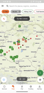
• Verschiedene interaktive, zoombare, vektorisierte, weltweite Wanderkarten mit allen markierten Wegen und Ihrer aktuellen Position
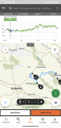
• Eine bequeme Möglichkeit, Ihre eigene Tour auf der Karte zu planen und sofort Länge, Dauer und Höhenprofil abzurufen
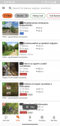
• Mehr als tausend empfohlene Touren für Wanderer, Biker, Trailrunner und Kanufahrer, mit praktischen Daten, detaillierter Beschreibung der besten Sehenswürdigkeiten in der Nähe, Natur- und Kulturhintergrund, hochwertigen Fotos und Informationen zur Anreise
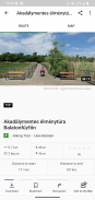
• Tausende von empfohlenen Sehenswürdigkeiten in Ungarn, darunter Aussichtstürme, Naturpanoramapunkte, Waldzüge, Festungen und Museen, mit ausführlicher Beschreibung, hochwertigen Fotos und Informationen zur Anreise
• Hunderte Unterkünfte, darunter Hütten, Touristenhotels und Apartments, in der Nähe markierter Wanderwege
• Nützliche Sammlungen mit Kartenansicht: Strände rund um den Plattensee, Eislaufplätze, Botanische Gärten, die besten Trailrunning-Routen, Kletterorte, Touren für Menschen mit Behinderungen usw.
• Hinweise, Warnungen und Schließungen
• HerunterladenKartenausschnitte, Touren und Sehenswürdigkeiten zur Offline-Nutzung
• On-the-fly Navigation entlang der Route mit einem Live-Höhenprofil und Sprachanweisungen
• Zeichnen Sie Ihre Route auf
• BuddyBeacon: Teilen Sie Ihre Position live mit Freunden
• Die komplette Ungarische Blaue Tour, mit offiziellen Abschnitten und Routen, POIs und Unterkünften
• Synchronisieren Sie alle Ihre Inhalte zwischen Computer und Mobilgeräten, auf denen die App ausgeführt wird
• Überprüfen Sie die lokale Wettervorhersage
• 3D-Flug: eine virtuelle Vogelperspektive der Tour
• Nützliche integrierte Tools wie Gipfelfinder(Skyline) und Kompass mit Ihrer aktuellen Position
• Community-Dienste: Bewerten und teilen Sie Inhalte mit Ihren Freunden
Smartwatches mit WEAR OS von Google
Mit einem Blick auf Ihre Smartwatch erhalten Sie Informationen zu Ihrer GPS-Position auf der Karte. Sie können Tracks aufzeichnen, Tracking-Daten abrufen und entlang von Routen navigieren. Nutzen Sie die App-Kachel, um ganz einfach auf Routen in der Nähe zuzugreifen.
Exklusiv für Pro-Mitglieder
Gehen Sie überall hin: Outdooractive Pro funktioniert offline ohne Mobilfunk- und Datensignale. Außerdem können unbegrenzt Listen erstellt werden und die App ist werbefrei. Darüber hinaus stehen Ihnen Satellitenbilder, die einzigartige Outdooractive-Karte mit über 30 Aktivwegenetzen und offizielle topografische Karten folgender Anbieter zur Verfügung:
Großbritannien Ordnance Survey, Landranger, Explorer
Landinformationen zu Neuseeland
Utah USGS
Deutschland BKG
Österreich BEV
Schweiz swisstopo
Frankreich IGN
Spanien CNIG
Italien
Niederlande PDOK
Norwegen Kartverket
Dänemark Kortforsyningen
Schweden Lantmäteriet
Finnlands nationale Landvermessung
Japan GSI
Globale Karte
Exklusiv für Pro+-Mitglieder
Pro+ enthält außerdem offizielle Karten von Alpenvereinen sowie Premiumkarten von KOMPASS.
Wenn Sie Fragen oder Anregungen haben, besuchen Sie bitte
https://www.termeszetjaro.hu/hu/p/gyakran-ismetelt-kerdesek/41050512 /
Unsere Desktop-Version:
https://www.termeszetjaro.hu/
Folgen Sie uns auf Facebook:
https://www.facebook.com/Termeszetjaro.hu/
Kontaktieren Sie uns:
termeszetjaro@termeszetjaro.hu
Mehr über die TEKA-Karte:
http://www.termeszetjarokartya.hu/
Természetjáró, a túratervező – APK Informationen
APK Version: 3.18.4Paket: com.outdooractive.mtszNeueste Version von Természetjáró, a túratervező
Weitere Versionen


Apps in derselben Kategorie

Das könnte dir auch gefallen...


